Project Description
This project was designed to perform a multitemporal analysis of rivers and coasts using remote sensing with the aim of determining the feasibility of construction and improvement projects for docks in the municipalities of Guapi, Olaya Herrera, Novita, Buenaventura, Tumaco, El Charco, La Tola, and Mosquera, based on the river/coastal dynamics observed over the past 30+ years.
Project: ART No. SC 0188-19 – “Structuring infrastructure projects identified within the action plans for regional transformation under the Territorial Development Programs (PDET) in the departments of Nariño, Cauca, Valle del Cauca, and Chocó in PDET municipalities.”
Methodology
An exhaustive review of the literature related to river dynamics and remote sensing was conducted. Notable references included:
- "Geology, Geomorphology and River Dynamics Applied to River Hydraulics" (Vargas, 2012)
- "Multitemporal Analysis Of The Amazon River Between Corea Island (Colombia) And Aramosa Island (Brazil)" (González Rozo & Soto Castro, 2009)
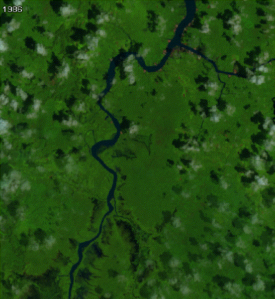
To visualize changes over an extended period, Landsat 5, 7, and 8 images were used. A JavaScript algorithm was programmed in Google Earth Engine to select images that met the following criteria:
- Coverage of the area of interest with image capture dates spanning at least 30 years up to the present.
- Cloud cover less than 25% within the selected area (not the entire image).
- Images captured within the same range of months (rainy season).
- Images corrected for geometric, radiometric, and atmospheric effects.
.png)
The algorithm iterated through the entire collection meeting these criteria and aggregated the images into an array. For each year, pixel values were averaged to create representative annual images. The resulting collection was clipped to the area of interest, date information was added, and an animated GIF was created to provide a visual overview of the changes.
Further Analysis & Outcome
Based on the visualized changes, the quality of the obtained images, and the time span analyzed, three images were manually selected for detailed comparison. A function was applied to compute the ICEDEX index to extract water pixels, and the results were vectorized. These partial results were analyzed with GIS software to measure channel changes and calculate migration rates in meters per year.
It was determined that the projected locations for three docks were not viable due to their placement in areas with high fluvial dynamics. In such cases, a change in the active channel would render the dock unusable either by erosion or by eventually being located in a dry zone. After multidisciplinary analysis — and considering the difficulty in relocating due to access issues — the recommendation was to use floating (non-rigid) docks that can be dismantled and moved, thereby adapting to changing environmental conditions at minimal cost.
Results: Channel migration rates were established as a key output of this analysis.
.png)
You can check the Google Earth Engine script here: Fluvial dynamics visualization.